Some of The Last Glaciers in The Tropics. They’ll be Gone in About a Decade

One of the most visible signs of Climate Change are the ways in which glaciers and ice sheets have been disappearing all over the world. This trend is not reserved to the Arctic ice cap or the Antarctic Basin, of course. On every part of the planet, scientists have been monitoring glaciers that have been shrinking in the past few decades to determine their rate of loss.
These activities are overseen by NASA’s Earth Observatory, which relies on instruments like the Landsat satellites to monitor seasonal ice losses from orbit. As these satellites demonstrated with a series of recently released images, the Puncak Jaya ice sheets on the south pacific island of Papua/New Guinea have been receding in the past three decades, and are at risk of disappearing in just a decade.
The Papau province of New Guinea has a very rugged landscape that consists of the mountains that make up Sudirman Range. The tallest peaks in this range are Puncak Jaya and Ngga Pulu, which stand 4,884 meters (16,020 feet) and 4,862 meters (15,950 feet) above sea level, respectively. Despite being located in the tropics, the natural elevation of these peaks allows them to sustain small fields of “permanent” ice.
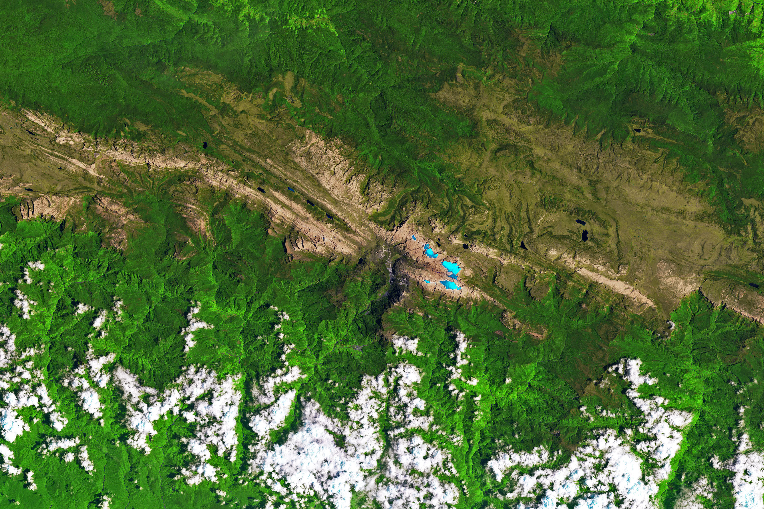
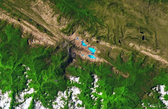
Image of the Puncak Jaya icefields, taken on Nov 3, 1988. Credit: NASA/EO
Given the geography, these ice fields are incredibly rare. In fact, within the tropics, the closest glacial ice is found 11,200 km (6,900 mi) away on Mount Kenya in Africa. Otherwise, one has to venture north for about 4,500 km (2,800 mi) to Mount Tate in central Japan, where glacial ice is more common since it is much farther away from the equator.
Sadly, these rare glaciers are becoming more threatened with every passing year. Like all tropical glaciers in the world today, the glaciers on the slopes around Puncak Jaya have been shrinking at a such a rate that scientists estimate that they could be gone within a decade. This was illustrated by a pair of Landsat images that show how the ice fields have shrunk over the past thirty years.
The first of these images (shown above) was acquired on November 3rd, 1988, by the Thematic Mapper instrument aboard the Landsat 5 satellite. The second image (shown below) was acquired on December 5th, 2017, by the Operational Land Imager (OLI) on the Landsat 8 satellite. These false-color images are a combination of shortwave infrared, infrared, near-infrared, and red light.
The extent of the ice fields are shown in light blue, whereas rocky areas are represented in brown, vegetation in green, and clouds in white. The gray circular area near the center of the 2017 image is the Grasberg mine, the largest gold and second-largest copper mine in the world. This mine expanded considerably between the 1980s and 2000s are a result of a boom in copper prices.
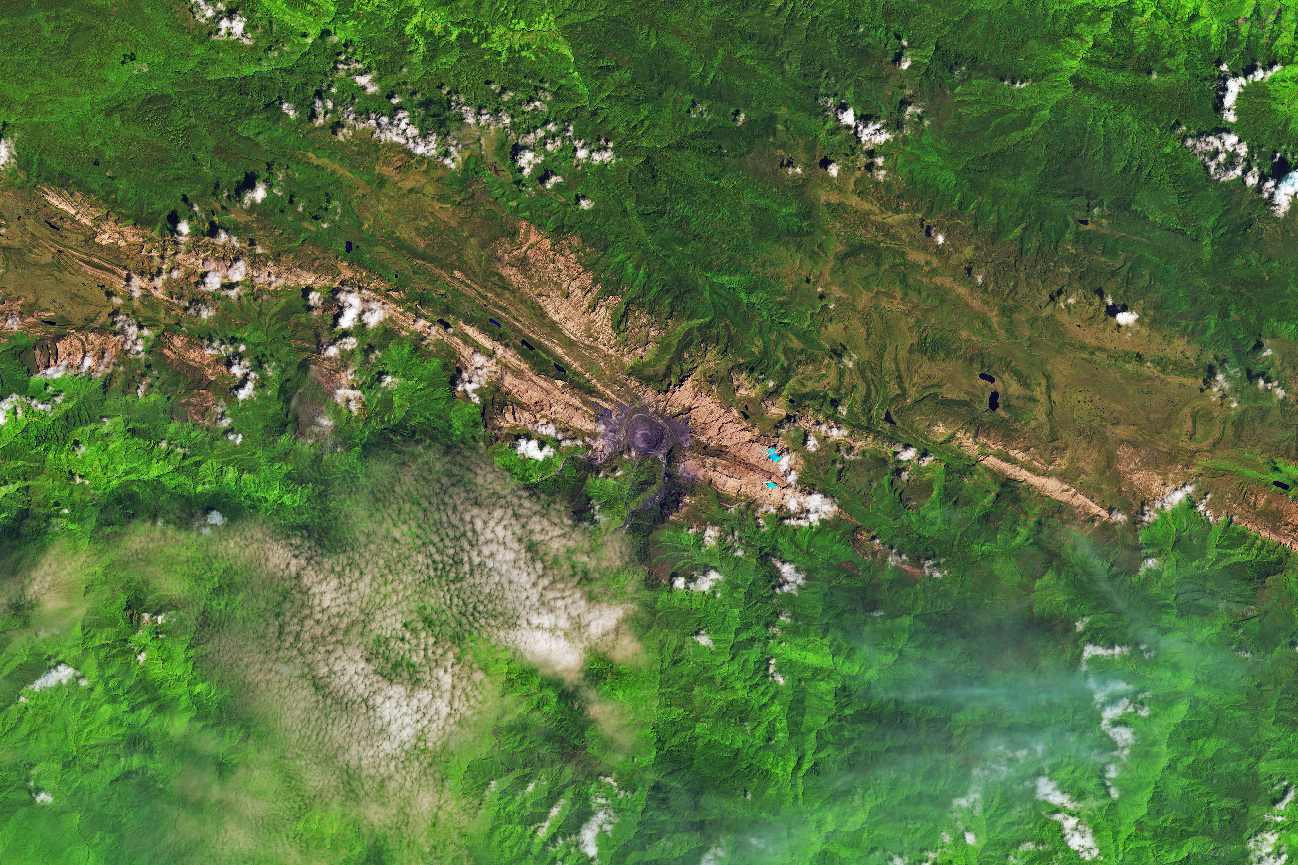
Image of the Puncak Jaya icefields in New Guinea, taken on December 5, 2017. Credit: NASA/EO
As the images show, in 1988, there were five masses of ice resting on the mountain slopes – the Meren, Southwall, Carstensz, East Northwall Firn and West Northwall Firn glaciers. However, by 2017, only the Carstensz and a small portion of the East Northwall Firn glaciers remained. As Christopher Shuman, a research professor at the University of Maryland Baltimore County and NASA’s Goddard Space Flight Center, explained:
“The ice area losses since the 1980s here are quite striking, visible in the contrast of the blue ice with the reddish bedrock. Even though the area still gets snowfalls, it is clearly not sustaining these glacial remnants.”
Similarly, in 2009, images taken by Landsat 5 of these same glaciers (see below) indicated that the Meren and Southwall glaciers had disappeared. Meanwhile, the Carstensz, East Northwall Firn and West Northwall Firn glaciers had retreated dramatically. Based on the rate of loss, scientists estimated at the time that all of Puncak Jaya’s glaciers would be gone within 20 years.
As these latest images demonstrate, their estimates were right on the money. At their current rate, what remains of the Carstensz and East Northwall Firn glaciers will be gone by the late 2020s. The primary cause of the ice loss is rising air temperatures, which leads to rapid sublimation. However, changes in humidity levels, precipitation patterns and cloudiness can also have an impact.
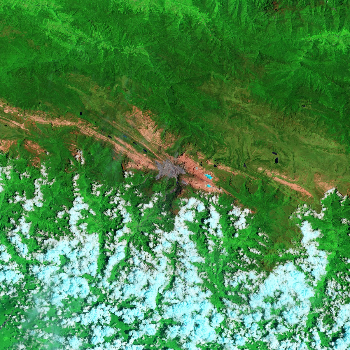
Image of the Puncak Jaya icefields in New Guinea, October 9, 2009. Credit: NASA/EO
Humidity is also important, since it affects how readily glaciers can lose mass directly to the atmosphere. Where the air is more moist, ice is able to make the transition to water more easily, and can be returned to the glacier in the form of precipitation. Where the air is predominately dry, ice makes the transition directly from a solid form to a gaseous form (aka. sublimation).
Temperature and precipitation are also closely linked to ice loss. Where temperatures are low enough, precipitation takes the form of snow, which can sustain glaciers and cause them to grow. Rainfall, on the other hand, will cause ice sheets to melt and recede. And of course, clouds affect how much sunlight reaches the glacier’s surface, which results in warming and sublimation.
For many tropical glaciers, scientists are still working out the relative importance of these factors and attempting to determine to what extent anthropogenic factors plays a role. In the meantime, tracking how these changes are leading to ice loss in the tropical regions provides scientists with a means of comparison when studying ice loss in other parts of the world.
As Andrew Klein, a geography professor at Texas A & M University who has studied the region, explained:
“Glacier recession continues in the tropics—these happen to be the last glaciers in the eastern tropics. Fortunately, the impact will be limited given their small size and the fact that they do not represent a significant water resource.”
Satellites continue to play an important role in the monitoring process, giving scientist the ability to map glacier ice loss, map seasonal changes, and draw comparisons between different parts on the planet. They also allow scientists to monitor remote and inaccessible areas of the planet to see how they too are being affected. Last, but not least, they allow scientists to estimate the timing of a glacier’s disappearance.
Click on the posted images to enlarge the ice fields, or follow these link to see image comparisons.
Further Reading: NASA Earth Observatory
The post Some of The Last Glaciers in The Tropics. They’ll be Gone in About a Decade appeared first on Universe Today.
Universe Today
Go to Source
Powered by WPeMatico